Our Review of the Top RV Trip Planning Services
Travel planning as a service has become a big business. Just a quick Internet search for “RV Travel Planning Services” generates dozens of “hits.” Not all of the leads, however, really focus on “RV Trip” planning.
 Source: pixabay
There are several services that stand out and we have taken a quick look at these. All of these online trip planning services are membership services and require an annual paid membership. Some offer free 7-day trials that let you do basic planning for a limited number of destinations, but even then, most required membership to take full advantage of their features.
Of course, you could use a typical auto club trip planner for most travel services such as mapping, stops, attractions, and even campgrounds. We have reviewed several “RV Trip Planning” services.
We have also included an alternative approach—Self Planning. Two years ago, we planned a 21-day trip with our camper from Tennessee to Kentucky, Indiana, then direct to Colorado, Utah, Wyoming, South Dakota, and return. We will go through the pros and cons of self-planning versus using a trip planner.
Some features we looked for in RV Trip Planning services were:
- Daily or destination point-to-point routing.
- Identification of all available private and public local, state, and national campgrounds.
- Clear routing to our specific destinations.
- Identification of historic, geographic, or cultural sites along our routes.
- Offers a free limited service
Our Top Online Trip Planners
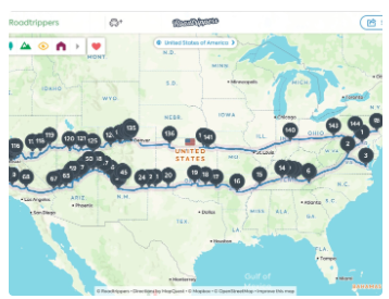
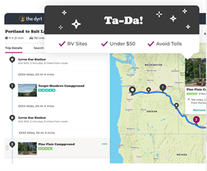
1. RoadTrippers (RV Trip Wizard – RV Trip Planner & RV Safe Routes)

RoadTrippers offers what amounts to a comprehensive trip planning service. Trip planning begins with at least one or more destinations that you identify. RoadTrippers allows you to create a route of as many as 150 stops—quite enough for even extended vacation trips. Their website claims “8 million points of interest.”
Using their online planning application, you enter your destinations, and answer a few questions regarding the types of roads you want to use or avoid. For example, you can avoid Interstate highways. You can also specify how far in distance, or how long in time you want to travel each day. Once you have completed the route planning, you can transfer it to a smart phone or tablet device to use in your vehicle for navigation. The service is available in both Apple App and Google Play stores.
RoadTrippers offers a free planning service that you can use as often as you like, but it is limited to just a few key destinations and does not include all RoadTrippers package of extensive services. For longer trips and to access all of their planning features, the annual subscription is $29.99 per year.
With this service, they can tailor your trip to avoid specific types of roads, for example Interstates, toll roads, or highways with steep grades.
A feature we like with any planner is that they identify points of interest within a reasonable distance from the route of travel. And since the planned trip is transferred to your mobile device, you can, if you wish, share your travels with friends as you go—you might even get a suggestion from one of your friends of a place to stop.
Like most travel services, they offer discounts—from their “travel partners”—that may include restaurants and local attractions. These specials appear as you enter destinations on the planning map.
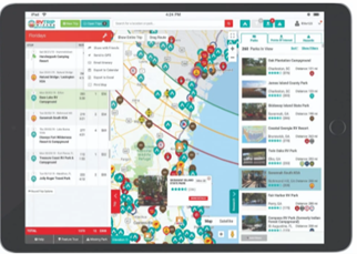
2. RV Trip Wizard

Their lead line reads “Save time, plan safe RV routes, find great campgrounds.”
Their services are typical—they offer a “Visual RV Trip Planner” that includes not only your route but “campgrounds, gas stops, and points of interest” along the route. They are not associated with any specific brand of campgrounds and claim “20,000 of reviewed campgrounds” with details of the available hookups at each campground. They also boast 10 million “data points” that describe points of interest.
A useful feature, especially for larger RVs, is planning that customizes routes to accommodate the heights and weight of your RV, identifying low clearances, steep grades, and any propane restrictions.
They do, however, allow you to rank any campground memberships you may want to use so you can easily identify KOA, Good Sam, Yogi Bear, or other campground brand with which you are affiliated.
One feature we like is their Trip Cost Estimating Tool that helps manage fuel costs and campground fees. Again, since these services are live online, they update local fuel costs and other camping expenses as you travel.
They include all commercial and public campgrounds—you are not “steered” to a specific brand of campground. Of course, in this age of technology, the mapping feature works on any Web browser, and mapping is as up-to-date as current Internet data.
RV Trip Wizard has a complete, step-by-step planning guide to ensure that you get the most useful information from their service. The RV Trip Wizard service is $49 per year. There is a 7-day free trial period, but you must sign up—and cancel before the seven days expire.
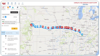
3. Good Sam

As part of your membership, Good Sam offers a travel planner, but it is several mouse clicks down in the basic Good Sam online site. Their Trip Planner features tools such as point-to-point planning, and has access to thousands of points of interest, and will identify what is available along your planned route. It too offers the option avoid toll roads as well as roads with low overhead clearances.
Their trip planning is broken down into “popular” destinations, i.e., regions of the United States, which is a good way to plan a trip. We particularly like the preplanned route along the road to Alaska. This route takes you through Alberta (think rodeos), the Canadian Rockies (mountain vistas and dinosaur fossils), and all the way to Fairbanks, Alaska. If you are looking for real travel adventure idea, check out Good Sam’s “Roads to Adventure”
You can also plan your individual trip using their planner. While Good Sam will identify a variety of campgrounds, it prominently features Good Sam parks along and near your planned route.
Because this is part of the complete Good Sam membership, you also benefit from all the other services they provide, including roadside assistance.
Good Sam membership prices range from $29 for one year to $79 for three years.
4. “The Dyrt”
“The Dyrt” is described as “the fastest-growing camping app on the web and mobile devices.” “The Dyrt” offers search and planning features, similar to other apps. However, their basic approach is somewhat different. They offer “recommended trips.” So, if you want a new adventure and are not sure where to begin, look at one of their recommended trips.
The Dyrt focuses on the camping experience and includes sources of free camping on Bureau of Land Management (BLM), U. S. Forest Service, and National park Service lands.
According to Sarah Smith, Founder of The Dyrt, “With the most campground reviews and largest database of campgrounds, The Dyrt is uniquely positioned to be the camping-for-all one stop-shop.”
They offer to help you find camping along any route and to find camping from your car without Wi-Fi.
They also encourage you to identify your driving and camping preferences, which like other services allows their planning software to tailor the trip, taking into account your camping rig and size, and other preferences. This includes the route and highly-rated campgrounds along the route.
Dyrt is not your more typical camping planner and will appeal to those looking for opportunities that include camping “off the grid.”
5. Do-It-Yourself-Planning
While we recognize the value and service of online RV trip planners, we consider planning part of the trip experience, building anticipation, and tailoring the trip to our specific preferences.
My wife belongs to a nationwide lady’s (only) camping and travel club. Based on the time away and distance, she asked if I objected to her taking the camper (from Tennessee) to Utah for a special club event. My response: it was fine as long as I could go along too. This set planning in motion.
We also needed some work done on the camper, and the factory, in Indiana, had agreed to do the work. All we had to do was set the date and get the camper there.
One of the best aspects of our planning was that it allowed us to take brief side trips to “pop-up” opportunities. For example, we might see signs indicating a museum or other point of interest. On most legs of the trip, we could detour at least long enough to take advantage of several pop-up opportunities.
Initial Planning
This set in motion initial planning for our grand adventure, taking advantage of the Utah event, we had the opportunity to visit other places on our travel bucket list, including Yellowstone National Park, Mount Rushmore, and Devils Tower Monument. Also, acknowledging our travel style that includes stopping at any place along the way that seems interesting, we planned to travel at a leisurely pace, using approximately 300-miles-per-day as our initial travel pace.
Based on those dates, we could go more-or-less directly—at a leisurely pace—to Bryce Canyon. The other thing we planned was to take our time and take advantage of our trip, especially once we left Indiana.
What you need to plan and complete your own trip:
- Road Atlas (you cannot beat paper maps or an atlas for high level planning)
- Appropriate State Road Maps (larger scale, more current information than atlas maps)
- Campground Directory
- A GPS Navigator
- Cell Phone
- Note Pad and Pen
Serious Planning
Planning was straightforward and simple. We got two current copies of national road atlases (one for each of us). Then we marked the places that were hard dates in our schedule. The first hard date was the event in Utah—a meet-up of several hundred women campers outside of Bryce Canyon National Park. (Note, the event was a “women’s only event,” so I had to plan several nights of tent camping elsewhere).
We planned our trip in roughly 300-mile-(approximately six hours driving)-legs each travel day after leaving Indiana. All mileages and routes were initially identified using Google maps, and we wanted to avoid Interstates wherever possible.
For planning, we used the road atlas and Google Maps to select general routes, and major “must-see” stops. But we had factored enough flexibility into the schedule to take advantage of the “pop-up” opportunities. We made only one campground reservation prior to departure, and that was in Grand Junction, Colorado. That would put us within distance for an easy drive to Bryce Canyon. Other than Grand Junction and Bryce Canyon (and the motel in Indiana), we made no other reservations for nights before departing home. All subsequent reservations were made a day or two in advance (sometime the same day) as we traveled, using a comprehensive campground directory.
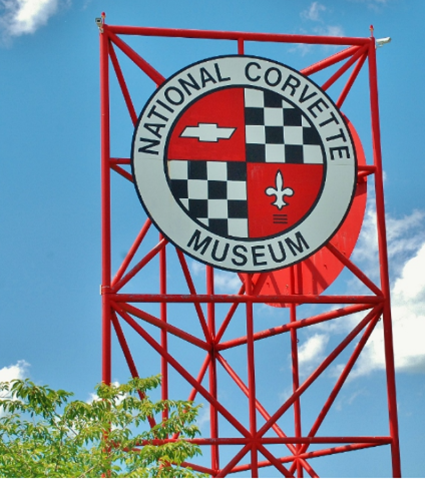
Our first “pop-up” stop occurred only about three hours into our trip in Kentucky, when we saw the sign to the National Corvette Museum in Bowling Green. That stop took two-plus hours but included a meal.
From there we traveled north to Indiana, stopping at an overnight rest area before the last few miles to the camper factory. We spent two nights in a motel while the factory had the camper—the only time we were not camping.
Leaving Indiana two days later, we had anticipated taking I-70 to Denver, but, checking maps, decided to try US highway 36 that parallels I-70 into Colorado. It was a great road with little traffic, and we made better time. Travel plans must allow for some flexibility.
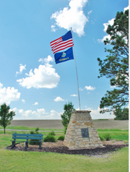
Our next pop-up event occurred on US 36 when we saw a marker that directed us to the “center of the contiguous United States.” We had about a minute to make a decision. We made the turn and were there within 15 minutes.
Using our camp directory, we found two nice campgrounds along US 36.
We continued to the end of US 36 and onto I-70 to travel through Denver to Grand Junction. The next day, it was an easy drive into Bryce Canyon.
From Bryce Canyon, we had planned to see the Grand Tetons, plus two days in Yellowstone, before beginning the trek eastward. We enjoyed the scenic drive to Cody, where we camped, and then on toward Devil’s Tower National Monument and Mount Rushmore. Along the way we had several more pop-up opportunities, including the Museum of Flight and Aerial Firefighting (I stop at all aviation themed museums!) in the town of Greybull, Wyoming.
Our next stop was Moorcroft, Wyoming, enroute to the Devils Tower National Monument. Devil’s Tower had been on my bucket list since the movie “Close Encounters of the Third Kind.”
From there we went to Custer, Wyoming, where we would spend two nights, and visit Mount Rushmore, which to, me was well worth the trip. While camping in Custer, we met other campers who were traveling in the opposite direction, telling us they had come through the Badlands National Park in South Dakota. We added the Badlands to our pop-up list. On the way to the Badlands, along I-90, we had pop-up stop at Wall Drug Store—it is a destination in itself, then through the Badlands, and the next pop-up, the Minuteman Missile National Historic Site, that was directly across the intersection exiting the Badlands.
The next day, having satisfied our bucket list for the trip, as well as a number of interesting pop-up events, we began the remaining two-day trek toward home.
For us, planning our trips is part of the experience. Granted, a planning service may provide additional information that we could have used, but our trip was a everything we had hoped.